The Leeuwin
The 1622 voyage of the Dutch ship Leeuwin (meaning "Lioness" in Dutch) is one of the most significant yet mysterious chapters in the early European exploration of Australia. The Leeuwin was a 400-ton yacht operated by the Dutch East India Company (VOC), specifically owned by its Amsterdam Chamber. It was not a large warship but an advysjacht (advice yacht), a versatile vessel used for carrying messages, orders, reconnaissance, and lighter cargo duties in support of the VOC's trade operations in the East Indies. The ship was fitted out between 1620 and 1621, with a crew of approximately 175 men for outbound voyages, though records indicate around 250 people were on board during its departure from Texel in 1621, likely including passengers or additional personnel.
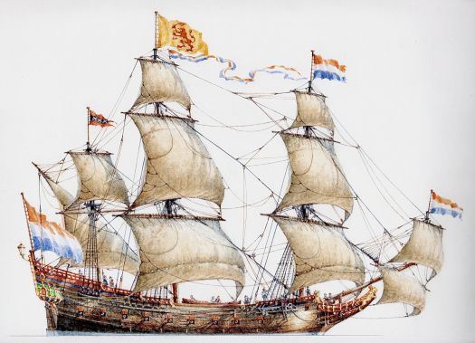
Watercolour of Leeuwin by Ross Shardlow
No contemporary images or drawings of the Leeuwin survive, but a modern watercolour interpretation by artist Ross Shardlow (created in 2022) depicts it as a typical Dutch galleon of the era, with three masts and a rounded stern.
The Leeuwin was one of several VOC vessels bearing the name between 1598 and 1664, reflecting the company's practice of reusing names for ships in its fleet. This particular ship completed five voyages to the East Indies, with its final voyage occurring in 1632. It was laid up in 1640 and eventually sold for scrap, marking the end of its service life. Its construction and operations were part of the broader Dutch Golden Age, during which the VOC, founded in 1602, dominated global trade in spices, textiles, and luxury goods from Southeast Asia.
Captain and Crew
The outbound captain of the Leeuwin during its 1621–1622 voyage was Jan Fransz van Hoorn (also spelled Franssen), a detail uncovered in 2022 through research by historian Dr. Nonja Peters, who examined newly digitized Dutch archival documents, including a diary entry by Arnoldus Buchelius dated March 1621. This identification resolved a long-standing historical mystery, as earlier sources simply referred to the captain as "Jan Fransz" without the full name. For the return voyage from Batavia, the captain was Dirk Gerritsz Krul, appointed on August 31, 1622.
Little is known about the specific crew members, as the ship's logbook has been lost. However, VOC crews typically included sailors, navigators, merchants, and sometimes soldiers or artisans. The extended duration of the voyage (over a year) suggests challenges such as adverse weather, which would have tested the crew's endurance.
The 1621–1622 Voyage
The Leeuwin departed from Texel in the Netherlands on April 20, 1621, bound for Batavia (modern-day Jakarta) in the Dutch East Indies. Its cargo included silver reals and other goods valued at 106,659 guilders. The voyage was unusually long, taking 13 months to reach Batavia on May 15, 1622, far exceeding the typical 4–6 months for similar trips using the Brouwer Route. The Brouwer Route was established in 1611 by Hendrik Brouwer, which involved sailing south to catch westerly winds. VOC letters attribute this delay to poor navigation: after stopping at Cabo Verde, the ship took an easterly course into the Gulf of Guinea, where it was stalled for about six months, from June 1621 due to adverse winds. This detour coincided with the formation of the Dutch West India Company (WIC) on June 3, 1621, raising speculation that the Leeuwin may have played a covert support role in early WIC activities.
Upon resuming, the ship sailed south and, due to navigational errors, veered eastward earlier than planned, leading to an accidental encounter with the Australian coast in March 1622. After the discovery of the southwest coast of Australia, the Leeuwin continued to Batavia, where it delivered its silver cargo and assisted in the blockade of Bantam (June–July 1622), providing fresh food and weapons. It was refitted before departing Batavia on September 6, 1622, alongside the English ship Cleene Jems (with instructions not to trust the English). The return voyage went via St. Helena, arriving back in Texel on May 19, 1623.
Discovery of the Southwest Corner of Australia
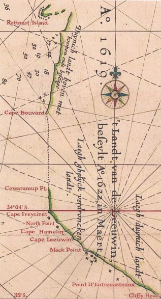
The Leeuwin's most significant contribution was its accidental discovery and mapping of approximately 150 km of Australia's southwest coast in March 1622, making it the seventh European ship to sight the continent. This occurred at latitudes around 35° south, starting near Cliffy Head or Point Nuyts (close to modern Walpole) and extending northwest to Cape Freycinet at 34°05'S. The crew charted features including Point D’Entrecasteaux, the Meerup and Yeagarup Dunes, Cape Hamelin, North Point, and Cape Freycinet, while skirting offshore islands and reefs to avoid hazards. Descriptions from the charts include "Duynich landt boven met boomen ende boseage" (dunes with trees and underwood), "Laegh ghelijck verdroncken landt" (low land seemingly submerged, referring to Flinders Bay), and "Laegh duynich landt" (low land with dunes).
The ship nearly shipwrecked near what is now Cape Leeuwin, but there is no evidence of anchoring or landing, though a cryptic rebus on a 1627 chart suggests a possible landing at Cape Freycinet, where a sandy beach and freshwater spring exist.The land was named 't Landt van de Leeuwin (Land of the Leeuwin), and the discovery was accidental, as noted in 1644 instructions to explorer Abel Tasman, which described similar sightings by earlier ships like the Eendracht (1616), Mauritius (1618), Amsterdam and Dordrecht (1619). The VOC showed little interest, as the land appeared barren and offered no trade benefits, leading to no immediate colonization.
This mapping was incorporated into Hessel Gerritsz's 1627 chart, "Caert van't Landt van d'Eendracht" (Chart of the Land of Eendracht), an early compilation of Dutch explorations of Western Australia's coast from 1616 to 1622.
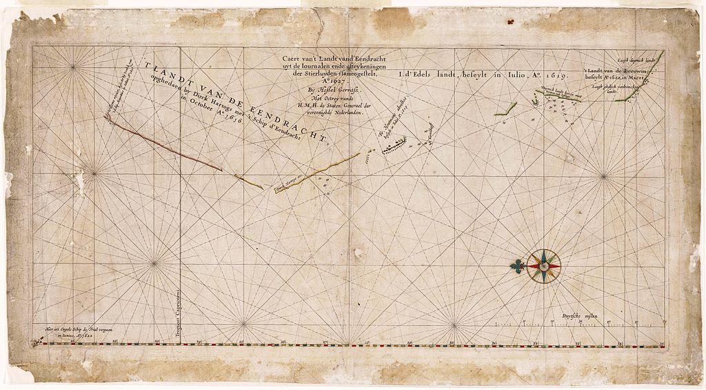
Caert van 't Landt van d'Eendracht (Note: North is oriented to the left)
Source: Maritime Heritage Association Journal
For decades, the Dutch referred to the entire western half of Australia as Eendrachtsland. The chart is named after the ship Eendracht, captained by Dirk Hartog, who in 1616 was the first European to leave a physical record (a pewter plate) on the West Australian coast. It shows the Leeuwin's section at the top right labeled "'t Landt van de Leeuwin beseylt A° 1622 in Maert" (Land made by the ship Leeuwin in March 1622). The map is oriented with north to the left. It depicts approximately 1,900 km of Western Australia's coastline, from the Willems River (likely near modern Onslow or Ashburton River, around 21°–22°S) in the north, southward to about 35°S near modern Albany. The coastline is interrupted by unexplored gaps (e.g., Exmouth Gulf).
- Descriptions include:
- Duynich landt boven met boomen ende boseage - Dunes with trees and underwood/forest
- Laegh ghelijck verdroncken landt - Low land seemingly submerged or flood-prone
- Laegh duynich landt - Low land with dunes
Source: Wikipedia: Caert van't Landt van d'Eendracht
Historical Significance and Legacy
The discovery contributed to European knowledge of the "Great South Land" (Terra Australis Incognita), though it was part of a series of accidental VOC encounters driven by the Brouwer Route. It prompted later explorations, such as those by François Thijssen on the Gulden Zeepaerdt in 1627, which extended charting to 37°S and the Nuyts Archipelago. Abel Tasman's 1642 voyage built on this, naming the continent New Holland.
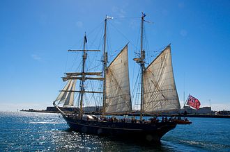
STS Leeuwin II
The name "Leeuwin" endures in Cape Leeuwin, the most southwestern point of mainland Australia, officially named by British explorer Matthew Flinders in December 1801. The cape, known to indigenous Wadandi Noongar people as Doogalup, marks the meeting of the Indian and Southern Oceans and features a 19th-century lighthouse. Other legacies include the Leeuwin Current (a southward ocean current along Western Australia's coast, unusual for its direction away from the equator, influencing marine life and circulation), a nature reserve, winery, suburb, and various businesses, as well as modern namesakes like the sail training ship STS Leeuwin II launched in 1986 in Fremantle, Western Australia, and used for youth programs.
Further reading
Maritime Heritage Association Journal - Leeuwin 1622–2022 Commemorative Edition